

Precision GPS Free

Precision GPS Free介绍
'Precision GPS Free' uses your device's GPS sensor to measure your location more accurately than is possible with typical GPS apps. Turn your phone or tablet into a precision GPS instrument.
Normally, software on your Android device determines your location from individual GPS readings. This is fine if your are interested in getting your location to within about 10 meters. However, it is possible to do better than this if you average many readings at a particular location.
This app is designed to do just that -- average many readings of a stationary Android device to get a more accurate location; it actually calculates a weighted average, accounting for the accuracy of each reading. The trade-off is time. You will need to wait a least a few minutes to get a high accuracy average location.
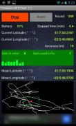
'Precision GPS Free' displays the following information on the main screen:
-'start/stop' button,
-'reset' button,
-battery power remaining as percentage,
-current latitude and longitude,
-round number,
-elapsed time,
-number of GPS satellites in view,
-number of GPS satellites employed in fixing location,
-signal-to-noise ratio of signal from each satellite,
-accuracy of the current readings,
-weighted average (mean) latitude and longitude,
-graph of the current latitude and longitude (white connected points) and the average value (red dot),
-bounding 'scale box' (green) around mean position with a width and a height of 2 meters.
The reset button is inactive while readings are being taken. It can be used after the 'stop' button is pressed. If the measurements are stopped and then started again without pressing the reset button, then only the 'elapsed time' value is reset.
The latitude and longitude values are shown on the graph. North is towards the top and east is toward the right, as in a map. The graph automatically rescales to include the extreme values of longitude and latitude each time it updates the graph (every four seconds). The green scale box is not always square in shape, since the graph latitude scale is not necessarily the same as the graph scale in longitude.
The app times out after 30 seconds if the device cannot get a satellite fix.
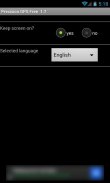
A 'settings' screen provides an option to keep the screen continuously on while the app is running.
Localization language support is provided for French, German, and Spanish.
This app does not save or transmit any personal information, including location or pictures. All the required permissions relate to the GPS operation and the ads.
Applications of 'Precision GPS Free' include navigation, geocaching, prospecting, emergencies, surveying a property, observational astronomy, and archaeology.
A pro version of this app is also available, called 'Precision GPS Pro'. It adds elevation and HDOP, PDOP, VDOP data and options to save the location (and copy to the clipboard), change the interval that readings are taken, display UTM coordinates, display a sky map of the active satellite positions, run in the background, change the format of the coordinates, and send the average coordinates to a mapping app, such as 'Google Maps.' The pro version is also ad-free.
If you have any suggestions for improvements or problem reports, please contact us at ggonzo47@gmail.com.
“高精度GPS免费”使用设备的GPS传感器能够更准确地衡量你的位置可能比典型的GPS应用程序。打开你的手机或平板电脑变成一个GPS精密仪器。
通常情况下,软件在Android设备上确定从单个GPS读数您的位置。这是好的,如果你有兴趣在约10米让你的位置。然而,有可能比这如果在特定位置处平均许多读数做得更好。
这个应用程序是专门做这一点 - 一个固定的Android设备的平均读数很多,以获得更准确的位置;它实际上计算一个加权平均值,占每个读数的准确性。权衡是时间。您将需要等待至少几分钟,以获得高精度的平均位置。
“高精度GPS免费”显示在主屏幕上的以下信息:
-'start /停止“按钮,
-'reset“按钮,
- 电池剩余电量百分数,
- 电流经纬度,
-Round号码,
-elapsed时间,
鉴于GPS卫星-number,
在固定位置使用的GPS卫星-number,
来自每个卫星 - 信号 - 噪声信号的比值,
当前读数-accuracy,
- 加权平均(平均值)的纬度和经度,
当前纬度和经度(白色连接点)和平均值(红点)的 - 图,
-bounding“规模盒子”(绿色)各地平均位置,宽度和2米的高度。
复位按钮是无效的,而读数上当受骗。它可以按下“停止”按钮后即可使用。如果测量被停止,然后再次启动不按下复位按钮,那么只有“经过时间”值复位。
的纬度和经度值显示在图形。北是朝向顶部和东部是向右,如在一个地图。图表自动重新调整,以包括经度的极端值和纬度在每次更新图形(每四秒)的时间。青鳞框不总是方形的形状,因为图纬度规模不一定相同经度图形尺度。
该应用程序超时30秒后如果设备无法获得的卫星定位。
A“设置”屏幕提供了一个选项,以保持屏幕上连续应用程序运行时。
本地化语言支持提供了法语,德语和西班牙语。
这个应用程序不保存或传输任何个人信息,包括位置或图片。所有所需的权限涉及到的GPS操作和广告。
“高精度GPS免费”的应用包括导航,寻宝,勘探,突发事件,测量属性,观测天文,考古。
这个应用程序的专业版也已经推出,被称为“高精度GPS临”。它增加了高度和HDOP,PDOP,VDOP数据和选项保存位置(复制到剪贴板),改变间隔读数取,显示UTM坐标,显示的有源卫星位置的星空图,在后台运行,改变坐标的格式,并发送平均坐标的映射的应用程序,如“谷歌地图”。 Pro版本也无广告。
如果您有关于改进或问题报告任何建议,请与我们联系ggonzo47@gmail.com。


